Tools Developed
This page lists the tools I have developed and that are openly available.
DPIRD Field Mapping Tool
Streamlit-based desktop application for digitising agricultural field trial plot boundaries over drone orthomosaics. Features grid generation, interactive polygon editing, multi-format vector conversion (Shapefile, GeoJSON, GeoPackage, KML) with CRS reprojection, and raster cropping. Distributed for Windows, Linux, and macOS.
(Will be openly available soon; currently under review by APPN)

IIQ to JPEG Batch processor
A simple GUI tool based on Python to convert the IIQ images to Geo-tagged JPEG format, utilising the maximum processing threads in a computer. The tool is dedicated to processing images captured by PhaseOne cameras mounted on UAVs for high-resolution imaging (sub-centimetre), while also preserving geotags and EXIFs for orthomosaic generation using software such as Agisoft Metashape.
(Will be openly available soon; currently under review by APPN)

Image Segmentation Pipeline
A workshop tutorial that I developed to present at Locate 2024, Sydney, that structurally explains how to train any image segmentation deep learning model with just a few lines of code. Below is the repository that contains Python modules for training and domain adapting any Encoder-Decoder Networks (EDNs). It includes comprehensive training and adaptation scripts with customisable settings for various segmentation tasks.
Datasets

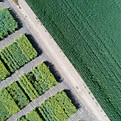
Banana Plant Detection Dataset
High-resolution UAV-based RGB image tiles over a 16-acre area with ~7000 banana plants collected at 30, 40, 50m altitude using DJI Phantom 3.
Data available upon request.
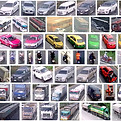
Thai Vehicle Classification Dataset
Around ~30000 samples for 7 vehicle types, collected from surveillance videos across Northern Bangkok.
Data available through GitHub.